
Satellite Channels
Overview
The GOES satellite senses electromagnetic energy at five different wavelengths. There are two wavelengths most commonly shown on weather broadcasts: Infrared and Visible.
Infrared
In the infrared (IR) channel, the satellite senses energy as heat. The earth’s surface absorbs about half of the incoming solar energy. Clouds and the atmosphere absorb a much smaller amount. The earth’s surface, clouds, and the atmosphere then re-emit part of this absorbed solar energy as heat. The infrared channel senses this re-emitted radiation. A major advantage of the IR channel is that it can sense energy at night, so this imagery is available 24 hours a day. This is a disadvantage of the visible channel, which requires daylight and cannot "see" after dark.

Visible Imagery
Visible satellite images, which look like black and white photographs, are derived from the satellite signals. Clouds usually appear white, while land and water surfaces appear in shades of gray or black.
The visible channel senses reflected solar radiation. Clouds, the earth's atmosphere, and the earth's surface all absorb and reflect incoming solar radiation. Since visible imagery is produced by reflected sunlight (radiation), it is only available during daylight.
One of the major advantages of visible imagery is that it has a higher resolution (about 0.6 miles) than IR images (about 2.5 miles), so you can distinguish smaller features with VIS imagery.

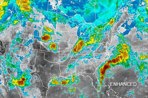
Enhancements
IR images are often colorized to bring out details in cloud patterns. Depending on the type of enhancement, the colors are used to signify certain aspects of the data, such as cloud-top heights. This is important because taller clouds correlate with more active weather and can be used to assist in forecasting.